[This information is from pp. 103-115 of Shovel Ready: Razing Hopes, History, and a Sense of Place: Rethinking Schenectady's Downtown Strategies, a master's thesis in city planning by Christopher Patrick Spencer (MIT, 2001), and is reproduced with his permission. It is in the Schenectady Collection of the Schenectady County Public Library at Schdy R 711 Spe.]
There is no such thing as perfect foresight, of course, so we can never plan infallibly, but we can face the urban future with modesty and an approach tempered by earlier successes and failures. In order to understand where we're going, it's necessary to know where we've been.
Witold Rybczynski, City Life: Urban Expectation in a New World
Every project or initiative that Schenectady undertakes in the downtown, as well as the planning assumptions it makes, has a direct impact on the downtown's direction and future. Each decision can either alter or reinforce that path. In addition to knowing where it's been, it's important to know where the downtown is now. By understanding this and considering the ongoing projects and future proposals, it is possible to gain greater insight into the downtown's direction and begin to envision what it might become.
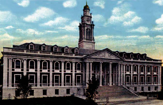
Like many neighborhoods, the downtown has no real boundaries. It contains a number of census tracts, political wards, and loosely defined districts. Bordering neighborhoods sometimes consider themselves part of the downtown. The limits of the downtown are constantly being defined and redefined according to the projects or initiatives being considered. Neither the 1924 or 1948 comprehensive plans for the city even refer to the downtown but instead to the Central Business District. The 1924 plan outlines the Central Business District as a circular zone with non-distinct or at least indistinguishable boundaries. The 1948 plan shows a general area but does not specify any boundaries. The boundaries specified for the 1999 Master Plan for Downtown Schenectady are listed as follows: Union Street on the North; Nott Terrace/Veeder Avenue/Millard Street/Broadway on the East; Interstate 890 on the South; and Washington Street [Avenue] on the West. Further this report states that "The study area generally conforms to the already designated Downtown Special Assessment District (DSAD) zone." (1)
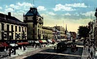
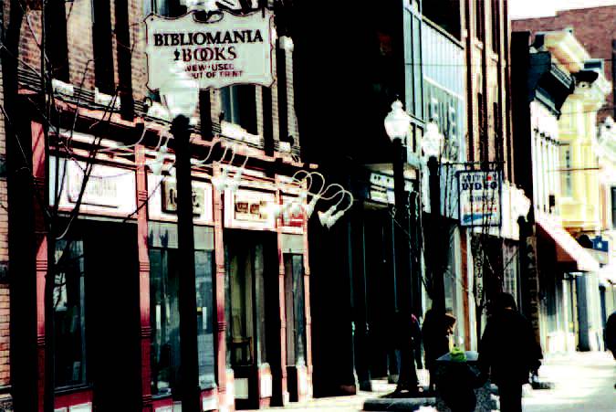
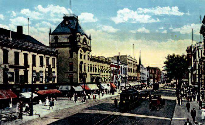
Typically, people refer to the downtown either in relation to a street, a section of a street, or the buildings or uses that border it. Lower Broadway typically is defined as that area of Broadway from State Street to Interstate 890. Lower Erie Boulevard is defined by the same two cross streets. The area around city hall is officially considered "Government Center" but is generally referred to as the city hall area. When people say they are going to Jay Street, they are usually referring to that section closed to vehicular traffic from Franklin Street to State Street. This area is also referred to in advertising as "Schenectady's Biggest Little Street." The urban renewal area has no name or prominent landmark building, but people often make references to the old Two Guys store. In fact many of the streets bordering it have so little character that many people don't even know what they are. The downtown is further divided along State Street. The section from Erie Boulevard to the Mohawk River is considered to be lower State or the lower portion of the downtown. From Erie Boulevard to Veterans Park is referred to as the upper part of the downtown or upper State. Upper State Street can also refer to any portion of State Street from Nott Terrace to the Niskayuna town line. In addition to these areas, there are a number of industrial areas within the boundaries as defined for the 1999 Master Plan. Whenever people refer to downtown, its not always clear what they have in mind. But typically, the image most associated with the downtown is the area along the spine of State Street from the Mohawk River to Nott Terrace.
Current Conditions
The image and the reality of the downtown has been deteriorating for years. Currently, as described in the previous chapter, much of the downtown could be considered to be low-road, or at least not filled with high-style examples of architecture. It might also be described as low-use, that is, the buildings are not being used in the best way to attract a diverse group of people. In addition, they are low-intensity because they do not create much interaction with the street.
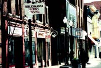
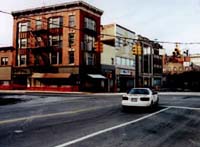
The south side of the upper State Street section, also known as the 400 Block or the former Canal Square development, exhibits some of the worst and best conditions in the downtown. One of the most prominent buildings in this area, The Hough Building, located on the Corner of State Street and Broadway, is now completely empty, cordoned off by safety barricades, and targeted for demolition. The remaining storefronts along the block are mostly vacant or covered over. Two exceptions are a well-maintained, temple front, neoclassical bank and the jewel of the downtown, a recently restored theater designated a National Historic Landmark. The opposite side of the street is a comprised of make-shift, in-fill construction — pizza parlors, sub shops, bargain stores, a pharmacy and the former Woolworth's. Its original tile façade was recently covered over with an artificial stucco during renovation for its new occupant, the New York State Commission on the Quality of Care for the Mentally Disabled.
Between Broadway and Erie Boulevard, still considered the upper section of State Street, there is only one surviving retail store, a center for alcoholic counseling for Schenectady County, an off-track betting parlor, an H & R Block office, a bank, and the Schenectady County Chamber of Commerce, plus a few holes where the Ellis and Bucci buildings once stood and where the entrance to Wall Street which led to the Union Station used to be. This block also suffers from two perceived edges which transverse State Street, interrupting the flow of pedestrian activity and the psychological connection with the lower parts of the street. One of these edges is the rust-colored overpass of the D & H railroad, which creates a dark stretch of sidewalk underneath. The other is created by the wide swath of pavement and busy automobile traffic along Erie Boulevard — dividing State Street and the downtown into a lower and upper section.
The lower section of State Street, although physically more intact and in better condition, is virtually empty above the ground floor except for apartments that are part of the adaptive reuse of the former Barney's Department store. Storefronts along this stretch contain only a few retail spaces and one bank. Others are a blend of social services, accountants, lawyers, and state offices. The remaining storefronts are either bricked over, contain interior shades, or have uses that do not create any pedestrian interaction or excitement. There are also a number of holes or "missing teeth" in the street wall as well as a number of buildings that have been decapitated through the loss of their upper floors. One of these gaps has been partially filled in with a combination KFC/Pizza Hut, bordering on a city parking lot. Perhaps one of the most unique experiential qualities of this section of street in relation to the rest of the downtown is the gentle curve of the street that begins near Erie Boulevard and continues until just past Church Street. This allows the pedestrian to experience only a few façades at a time, as they are gradually revealed as one walks along the street towards the Mohawk River. Where the curve straightens, the river and the bridge that takes State Street, or Route 5, across it to Scotia and beyond comes into view. To the left of this bridge is the historic Van Curler Hotel, now used as the Schenectady County Community College.
The section of State Street between Church Street and the Mohawk River, which also acts as the entrance to the downtown and the city from the west, contains a number of well-proportioned and appropriately-scaled buildings along one side including apartment buildings and the YMCA. On the opposite side, however, there is no sense of enclosure or continuity, with only a few buildings, a park, and a parking lot used to define an important arrival point and juncture where at least five streets converge. This is an area where the buildings and their uses should help celebrate the intersections and work to further reinforce and define the historic street pattern.
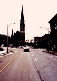
Fig 9.04 [enlarge]
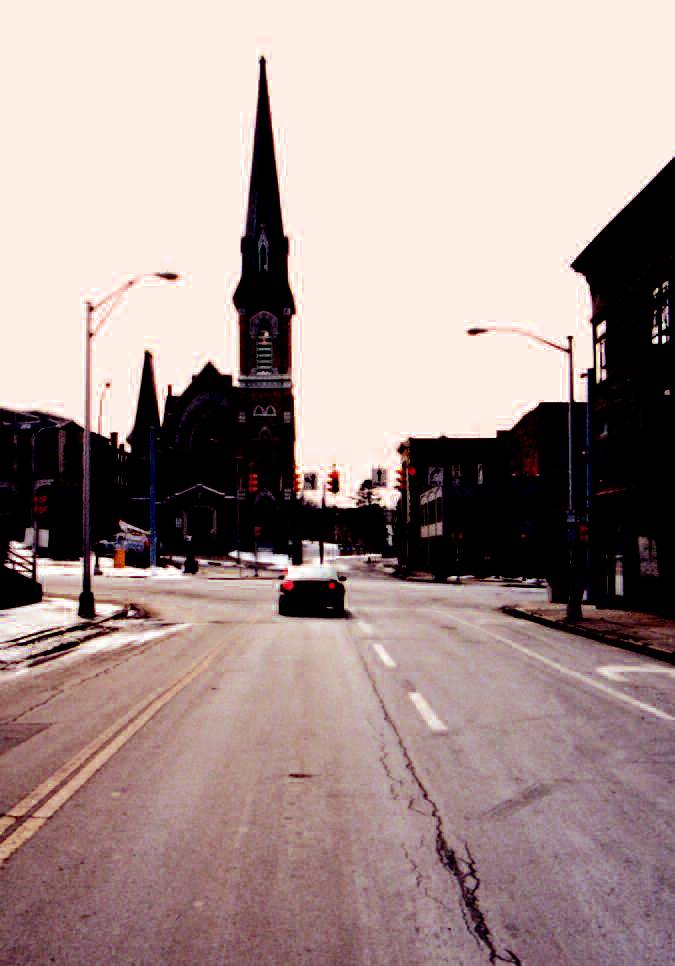
Church as focal point — southeast on Lafayette Street towards State Street at the foot of Veteran's Park.
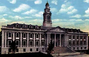
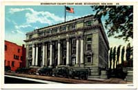
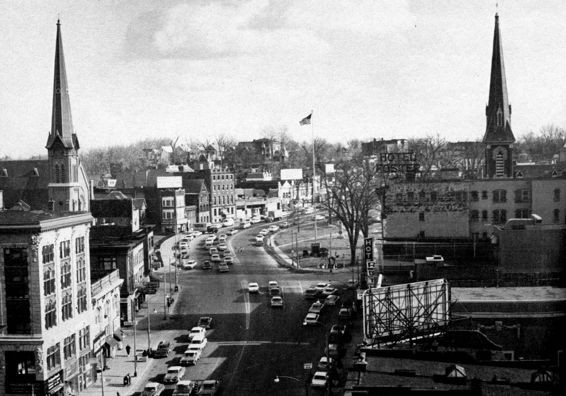
On the upper part of the downtown starting at Lafayette Street, State Street splits and curves around two sides of Veterans Park which runs up the hill until it meets Nott Terrace. One leg of State Street continues up the hill past Nott Terrace while the other leg becomes Albany Street, which also continues up the hill. Along one side of the park is Saint Joseph's Roman Catholic Church, a few small buildings, the Schenectady County Court House, and the county office building. Directly across the park from the courthouse and church is the State Street Methodist Church and rectory on the corner of Lafayette and State Street as well as another church, Emanuel Baptist, near the corner of State Street and Nott Terrace — with nothing in between. This side of the street had been composed of a number of narrow buildings that respected and reinforced the curve of the street. Among those buildings was the Plaza Theater, built in 1931 and demolished in 1964. The head of the park near the intersections of State Street, Albany Street, Veeder Avenue and Nott Terrace was once marked with the imposing presence of the heavily castellated state armory. Razed in 1947, that terminus is now marked with a Goodyear Automotive Service Center and a small memorial honoring Revolutionary War hero General Casimir Pulaski. (2)
Many other areas of the downtown mirror these characteristics and repeat the deficiencies. A number of the smaller streets have lost all identity and lack any sense of enclosure or dynamic, interactive uses. Most of the destruction in these other areas was undertaken to create additional surface parking. The short block of the Jay Street pedestrian mall is currently the only viable or very active retail section of the downtown. It is also one of the few areas in the downtown where more than two retail establishments in a row can be found. For the most part, the older buildings, like most in the downtown, are rectangular in plan with their narrow end facing the street. There are a few single story structures, but most of the buildings are two to three floors in height. The upper floors are more actively used by a number of design firms and other professional offices, as well as a few apartments.
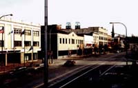
The visual terminus of the lower section of Erie Boulevard is marked by the historic General Electric sign. Years ago, the sidewalks on either side of Erie Boulevard would have been crowded and active at lunch time, with thousands of employees filing into the downtown for lunch. And twice a day, one side of the street would be crammed with cars — going to the plant in the morning, and then leaving at the end of the day. Starting around 4:30 P.M. in those days, a line of cars, often four abreast, would stretch from State Street back to the GE plant. At its height in Schenectady, well over 50,000 people were employed at General Electric. Today, employment at the plant is probably under 5,000. Most of the larger retailers along this street, including a hardware store that had been in business for over a century, are now closed. The street with no cars to fill it and the sidewalks with no one to walk them seem overly wide and barren. There is no sense of street wall along this stretch, and the buildings that do line it are too small and too few to provide any sense of enclosure or meaning for this once important route.
Fig 9.06 [enlarge]
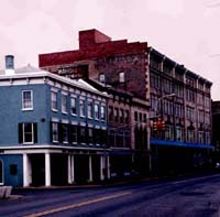
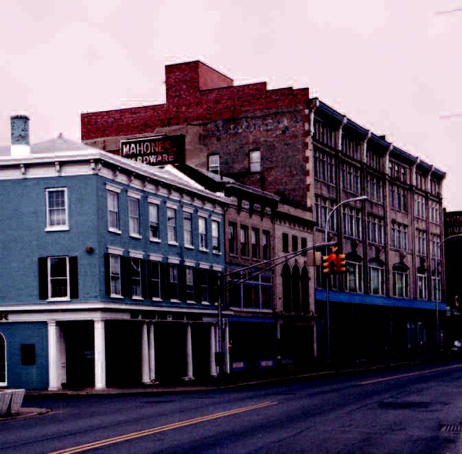
Pinhead Susan's on the corner of Liberty Street and Broadway. The other three corners are defined parking lots.
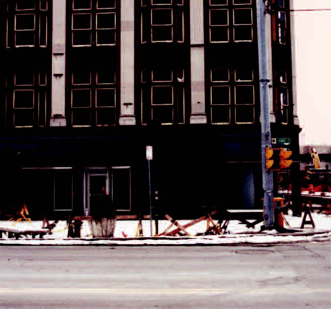
The upper part of Erie Boulevard, although much narrower than the lower section, has also lost much of its street wall and its story — today it is largely defined by parking lots and single story, warehouse quality buildings. One of the character-defining qualities of this section of the street is a massive through-truss bridge that was originally built over the Erie Canal and now spans the street on a diagonal, carrying the railroad tracks over the road just northeast of Union Street. In a number of other places the tracks pass over the streets in the immediate downtown. Along Erie Boulevard, the retaining wall of the raised tracks acts as an edge now that many of the buildings which once graced the street have been removed. In an effort to beautify the wall in the late 1990s, a group of volunteers painted it — covering over one of the city's most historic informal messages or acts of graffiti. Along the wall, perhaps well over 20 years ago, someone had spray painted the message "Susan is a Pinhead." It remained there for many years until the city painted over it. Soon after, a new message appeared; "Susan is still a Pinhead." Subsequently, that was covered over only to reappear with the new proclamation, "Susan remains to be a Pinhead." This time the entire wall was covered using a graffiti resistant paint. Last year, Pinhead Susan's reappeared as a new, upscale restaurant on the other side of the wall.
Soon another bit of history may "reappear." In 1968, Schenectady ceased to be a stop on the passenger rail lines, and a new station was built in the suburbs. By 1971, the fast moving city had torn down the majestic Union Station to make way for additional parking. By the mid-1970s, Schenectady was back on line and a new suburban-style station was built. Today the diminutive and already deteriorating Amtrak station (affectionately and appropriately referred to by some as Amshack) may go the way of the previous station, to make way for a grand new station — replete with details evocative of the old one.
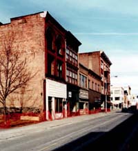
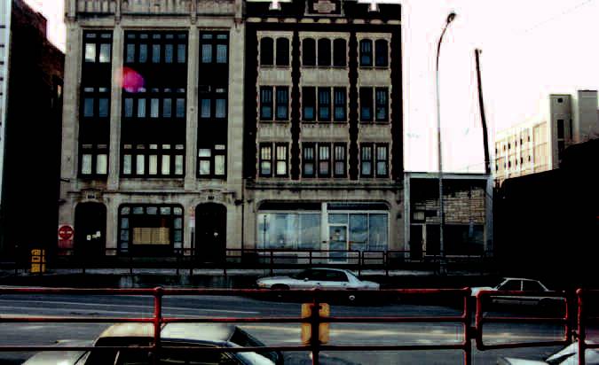
Lower Broadway, between State Street and Interstate 890, was once lined with two and three story buildings with shops below. Currently, there are few physical reminders of that era. Along one side is a multilevel parking deck, a single story market now used as storage facility, a large city-owned parking lot, and a number of small businesses interspersed between more parking lots. Along the other side there are one or two small businesses, a public housing project, and a new office building. Built in the late 1980s, it was slated to be the first of three identical towers in that area. The corner of State and Broadway is undergoing change, with at least eight buildings having recently been torn down to make way for the state's Department of Transportation [DOT] building. Broadway and Erie Boulevard run somewhat parallel, almost converging north of Union Street, but spreading farther apart as they move in the direction of Interstate 890. This land in between was once the point of convergence for a number of rail lines. There is no direct connection between Broadway and Erie Boulevard below State Street, restricting the their use. Both streets could support more intense development.
Current Projects
Despite the high vacancy rate in buildings throughout the downtown, two large office buildings are currently under construction. Although vacant land and more suitable parcels were readily available, the construction of one of these buildings has meant the demolition of at least eight buildings at one of the more prominent corners of the downtown. The other new building will occupy one of the more impressive sites in the downtown, across from the Schenectady County Courthouse and Veterans Park — one of the main entrances to the downtown. Both of these buildings will be occupied by single tenants. Those who lobbied for these sites have assumed that the office workers will add to the life of the streets and the financial benefit of the merchants in the downtown. Other projects that have been approved or are in the early planning stages include an intramodal transportation center and transportation museum, a redesigned streetscape for State Street from Nott Terrace to Erie Boulevard (including the re-introduction of on-street parking) and a multiplex theater with 12-30 screens and stadium-type seating.
One of the newest players in facilitating big development projects is the Schenectady Metroplex Development Authority. It was created by the State Legislature in 1998 as a public benefit corporation. Through this legislative action Metroplex have been given the power to "design, plan, finance, site, construct, administer, operate, manage, and maintain facilities within its service" as well as the powers of eminent domain. They are funded through county sales tax and receive "70 percent of one-half of one percent." This generated approximately $6.6 million in 1999 and $6.5 million in 2000. Currently they are involved in four projects that they project will create 364 new jobs. Their total contribution towards these projects in the form of grants is over $15 million. Initially many thought that through a tax revenue sharing that the downtown of Schenectady would be revitalized. But in fact, Metroplex's territory has now doubled from "23.7 square miles to 56.9 square miles" and involves development in a number of more suburban areas. Metroplex's mission is to "enhance the long-term economic vitality of life in Schenectady County by cooperative, purposeful actions and investments within the Metroplex corridor with particular emphasis on downtown." (3)
Department of Transportation [DOT] Building
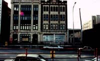
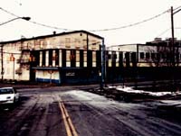
Fig 9.11 [enlarge]
Another potential site for the DOT building on the other side of the Broadway Garage and next to a large city-owned parking lot.
In an effort to help ailing cities like Schenectady, Governor George Pataki has been shifting a number of department headquarters out of Albany and into some of the surrounding communities. While the added presence of 300 or more workers may benefit the downtown, the move is typical of what many incorrectly refer to as job creation. In essence, most of these big development projects only entail job shifting or stealing from a nearby community. Few real jobs are added, vacancies are created in areas where the jobs came from, and often commute times are increased for the employees. Unless the lateral shift is substantial in distance, few will actually move to the new host community. In communities like Schenectady, there has been little emphasis on local economic development and little understanding of how local economies work. But perhaps the most counterproductive aspect of the DOT move is the siting of its new building.
The new building to be located on the corner of State Street and Broadway has already resulted in the demolition of a number of historic structures and the displacement of a few businesses. One of the buildings which was vacated a few years ago had previously been the headquarters for the Daily Gazette Newspaper. It had been at this location for over 100 years until it relocated to Maxon Road, where the city has created a new industrial zone along the city's last undeveloped stretch of riverfront. The premise behind the location of the DOT building was that it would provide easy access to the city parking garage, which is located just south on Broadway and would benefit the few merchants that are left. Another site was available on the other side of the parking garage along Broadway. This site would also have required the razing of a few structures, but they are single story buildings and not integral to the street wall or character of the main downtown street.
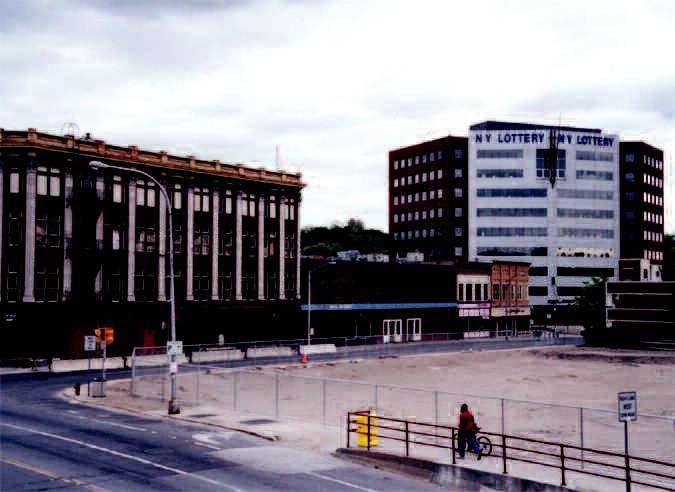
The rationale often given for not choosing the other side of the parking garage was that the workers would never walk back up to State Street or into the downtown for lunch or shopping. This alternative site would have put the DOT building across the street and just a few hundred feet down from the Broadway Center — part of a proposed office building complex designed to "revitalize the downtown of the city and create a series of buildings that would become the center of Schenectady." (4) Originally the center was to be composed of three 14-story office buildings, but only a single seven-story one was built. It is now home to the New York State Lottery, whose most famous advertising slogan is, "All you need is a dollar and a dream." It is often difficult, some authorities have argued, to encourage people to leave the Broadway Center and walk the hundred yards to State Street. A few hundred feet farther from the State Street, they felt, would have been disastrous. But it may also underscore the faulty assumption that these big office projects will have an enormous benefit on the downtown.
With the siting and program requirements for these types of projects as well as the dead spots they create, the city is in effect removing the opportunity and the potential for any lively street life they hope to create. In reality they are destroying the very essence and qualities which they say these projects will build on. It is analogous to paving over large portions of a park to accommodate all the people who come there to enjoy its natural setting. Given the fact that many of these new buildings are self-sufficient enough that people don't have to leave, the current head of Schenectady Economic Development Corporation said he is not in favor of designing ground floor retail into them because he wants to force people out onto the streets. But if more of these types of buildings are developed along the main street, there will not be much left for these people to leave the buildings for.
The design of the new DOT building, although perhaps better than anything the city has seen in the last 20 years or more, missed out on a number of opportunities that both the site and the process had presented. Street corners in a city represent choice and opportunity. They provide a choice in direction, and an opportunity and place for people moving in different directions to come together. Corners and intersections can be nodes of intense activity. The buildings that occupy them should celebrate this event. They should provide a visual clue that something more than a gap in the street wall is occurring. They should appear as if they are designed for that particular site, rooted to the ground, and respectful of their surroundings.
Moreover, the process could have provided an opportunity for the public to see all the designs that had been considered — not so they could vote on them, but so they might begin to imagine the possibilities. When the City of Chicago began to plan for a new public library, they made a decision to televise the jury process where the different designs were explored, critiqued, and explained. By the time the winning design was announced, the public had greater insight into the process and felt a part of it. It educated many of them about architecture and design, and provided them with the tools to better understand the built environment around them. In the end, the design chosen for the Harold Washington Library embodied the presence, knowledge, and seriousness typical of the iconography of public libraries, while representing and being respectful of a style that is distinctly Chicago.
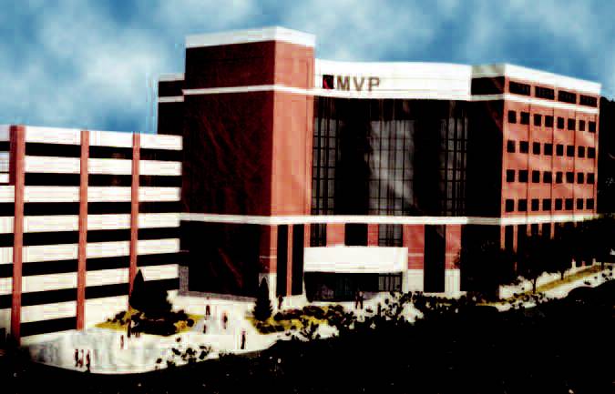
Mohawk Valley Physicians Health Care Plan, Inc. [MVP] Building

Fig 9.15 [enlarge]
Former buildings along Veteran's Park following the curve of the road. Now site of the MVP building. (See figure 9.16)
The new MVP building will be located on State Street and Nott Terrace, across from Veterans Park and the County Court House and Office building. The move for MVP is less than one mile from the County's first court house, an historic Greek Revival structure at 108 Union Street. The new location and building will allow MVP to consolidate several offices and provide room for expansion. The building and siting are wrought with many of the same issues as the DOT building. But perhaps one of the most glaring problems is the design of the building and its total disregard for the site and the buildings and uses around it.
The site, which has been vacant for a number of years, was the focus of a number of speculative projects and demolition proceeded on the assumptions that something big was about to happen. For many years the site was being readied for one of those "downtown saving" projects, a world trade center that never transpired. The scale and uses of the buildings that previously occupied this site helped to provide enclosure and uses which benefited the park. The buildings were narrow enough so that collectively they were able to follow the curve of the street. The design for the new building neither follows the curve nor steps up along the hill. It completely dwarfs State Street Methodist Church and rectory to one side, and disrespects it by placing its parking garage next to it. On the other end of the building, it completely obscures the view of the elegant rose window, tower and entire structure of the Emmanuel Baptist Church.
The building's massing, scale and blockiness make it almost impossible for it to respond well to the slope of the site or the curve of the street. Because of its long exposure and the slope of the site, the first floor belt course at one end of the building correspond to the fifth floor of the parking deck at the other end. It does not communicate or respect the buildings across the street, offering horizontal concrete abutments and brick pilings of the eight-level parking garage as a counterpoint to the massive Corinthian order of the County Court House.
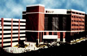
While the design might be at home in any suburban corporate office park, it has almost no urban or pedestrian qualities to make it "at home" or help it contribute to the sense of place in Schenectady. There is no reason for anyone who does not work in this building to interact with or even walk by it. And despite its massive taxpayer-subsidized parking garage, ($11.6 million) paid for through the Metroplex Development Authority, the parking garage will not be open to the public or be considered a shared lot to help local merchants because it is felt that MVP will grow quickly to occupy all 875 spaces. (5) Another assumption being made is that the MVP and DOT buildings will act as anchors, creating pedestrian movement in between. However, unlike mall anchors which give people a reason to walk between them and frequent the places in between, these are more likely to act as boat anchors — preventing movement. They give few reasons for the public to venture past them or even to them and will likely create more dead spots along the street, especially at night.
Large single use buildings such as the DOT building and the MVP building are also, in many ways, less adaptable then the smaller buildings that are more typical of a downtown. If in the future, the current occupants of either building leave, the space may be much harder to fill than smaller ones in the downtown. Unless another company with the same square footage requirements can be found, the buildings must be subdivided and rented to a number of smaller companies. In City Sense and City Design, Kevin Lynch talks about the difference in adaptability between fine grain and coarse grain environments and explains that while the course grain may be more adaptable if the use remains the same, it is less so when the uses change. The same is true with the buildings that are not intricately mixed into the surroundings. "Although it may seem that complexity, interdependence, and high communication are signs of a fragile organism, while a simple, independent one is tough and adaptable, in fact the reverse is usually true." (6)
The Direction
Although the DOT and MVP buildings represent only two of the current projects, they are indicative of the types of development that the city is likely to pursue. The Mayor is hopeful that the Governor will soon announce the shift of another major department with additional state jobs to Schenectady.
These projects illustrate in many ways that the city is focused on and continues to sponsor big-ticket development projects with hype and fanfare — proclaiming or implying that each one will save the city. While a number of sites would be more appropriate for this scale and type of development, the city stubbornly insists that they occur on or as close to the main spine of the downtown as possible. This will only further erode the fine grain of the downtown and result in the evaporation of many opportunities to strengthen and support the local economy. If the city is trying to create a downtown office park that offers little to its own community, and if it is only concerned with adding more people to the downtown during daytime hours, then it could be said that the city is on the right track. If, however, the goal is to create a more livable downtown with a mix of activities and users spread throughout the day, than the city needs to rethink its strategies. The city must begin to repair the breakdown in the grain of the city and the connections to the surrounding neighborhoods. By diverting some of the resources now spent on big projects, the city can begin to attract, retain, and enhance small businesses and expand the local economy. By focusing on projects and initiatives that add to the city's rich stories, the city can begin to build on its unique character, thereby, creating a marketable environment that will attract small and bigger businesses without the need for large taxpayer subsidies. In doing so it will add to the critical mass needed to sustain a number of projects that might benefit the community.