[View 9x enlarged version (426K)]
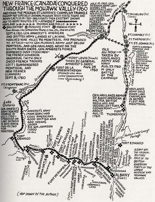
Map: New France (Canada) Conquered Through the Mohawk Valley — 1760 and over the Mohawk-St. Lawrence-Champlain Triangle
Diagram map especially showing Mohawk River forts, towns and Indian castles in 1760 — only forts then existent shown
Map drawn by the author
Key to army routes [Amherst, Haviland and Murray and Rollo are indicated, as are the symbols for English, Iroquois and French forts:]
Town Names like (Utica) show Towns, Cities, etc. now on sites.
Sept. 6, 1760, Gen. Amherst's American and British army landed at Lachine, marched nine miles to Montreal and prepared to attack — with Gen. Murray's army just below Montreal, and Gen. Haviland's army on the south river shore, Gen. Amherst's force numbered over 17,000 men — the French Governor Vandreuil (with only 2400 French troops left) surrendered Montreal and New France (Canada) Sept. 8, 1760
Forts listed: Fort Edward, Fort Ticonderoga, Fort Crown Point, Fort St. Johns (Fr.), Fort Therose (Fr.), Fort Chambly (Fr.), Fort Richelieu (Fr.) (Sorel, Quebec), Fort Albany, Fort Hunter, Fort Johnson, Fort Canajoharie, Fort Hendrick, Fort Herkimer, Fort Schuyler, Fort Stanwix, Royal Blockhouse, Fort Brewerton, Fort Oswego, Fort Frontenac (Fr.) (Kingston, Ontario), Fort de la Presentation (Fr.) also then called Oswegatchie (now Ogdensburg), Fort Levis (Fr.)
[Notations on the route from Fort Ticonderoga to Montreal:]
- Gen. Haviland's army of 3400 American militia, British regulars and Indians left Fort Crown Point about Aug. 1, 1760
- Haviland's army sails down Lake Champlain in armed fleet for Montreal
- Isle Au Noix taken by Haviland's army and navy Aug. 27, 1760 in only battle of the campaign
- Forts Chambly, Therose and St. Johns taken by Gen. Haviland's American-British army and navy after the Battle of Isle Au Noix
[Notations on the route from Albany northwest to Fort Oswego and then northeast to Montreal:]
- Gen. Amherst's main body American-British army of 10,000 men mobilized at Schenectady and left thee, June 12, 1760, for Oswego, 160 miles over Mohawk River and river roads
- Gen Amherst's army reached Oswego in July, 1760 — embarked on Lake Ontario in 800 boats Aug. 10, 1760 for Montreal
- Amherst's army (main body) had 6000 Americans, 4000 British and 600 Indians under Sir William Johnson, 11,000 in all
- Fort de la Presentation (French) also then called Oswegatchie (now Ogdensburg)
- Fort Levis (French) taken by General Amherst's army Aug. 25, 1760
[Note in lower right corner:] Albany was the colonial military base of the British-American forts of the Upper Hudson and Mohawk Valleys.]