[View 4x enlarged version (404K)]
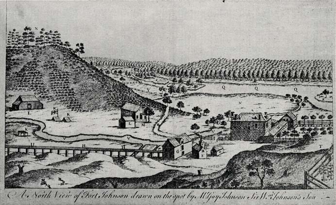
Map: A North View of Fort Johnson drawn on the spot by Major Johnson Sir Wm. Johnson's Son
(Courtesy of John Fea, Amsterdam.)
Explanation of the View
- A — The house, or Fort Johnson.
- B — The wall and ramparts.
- C — The block-house in the corner, on the front, and barracks that flank the gate; the same on the other side.
- D — Cooper's house.
- E — The bake-house.
- F — A pigeon-house.
- G — The mill.
- H — An aqueduct from the mill-dams to the mill.
- I — The Indian council-house.
- K — Indian encampments.
- L — A sheep-house; but now there is a blockhouse built there.
- M — A very large barn and stables.
- N — Mount Johnson, very steep.
- O — The house where Sir William Johnson lived [1739 or 1742 until 1749) before he moved (Jan., 1749-50) into A.
- P — The barn for ditto.
- Q — The Mohawk river.
- R — Part of an island opposite to the fort, 100 acres.
- S — Thirteen smaller islands belonging to Sir William Johnson.
- T — Another block-house, to defend the back of the house.
- V — A fine creek that runs by the fort into the river.
- W — A garden.
- X — Fine pastures.
- Y — Corn-fields.
- Z — The road to Schenectady.
[NOTE: Guy Johnson was not Sir William's son. He was his son-in-law. See next chapter for description of Fort Johnson in 1757 by the French spy of that year.]