This page conforms to the XHTML standard and uses style sheets. If your browser doesn't support these, you may not see the page as designed, but all the text is still accessible to you.

SCHENECTADY DIGITAL HISTORY ARCHIVE

Bringing the heritage of Schenectady County, New York to the world since 1996

You are here: Home » Resources » MVGW Home » Maps » New York State Geological Provinces

History of the Mohawk Valley: Gateway to the West 1614-1925
New York State Geological Provinces

[This information is from Vol. I, p. 51 of History of the Mohawk Valley: Gateway to the West 1614-1925, edited by Nelson Greene (Chicago: The S. J. Clarke Publishing Company, 1925). It is in the Reference collection of the Schenectady County Public Library at R 974.7 G81h. This online edition includes lists of portraits, maps and illustrations. As noted by Paul Keesler in his article, "The Much Maligned Mr. Greene," some information in this book has been superseded by later research or was provided incorrectly by local sources.]

Contents | Biographies | Illustrations | Maps | Portraits

Go back to: Chapter 1

New York State Geological Provinces.

[View 4x enlarged version (115K)]

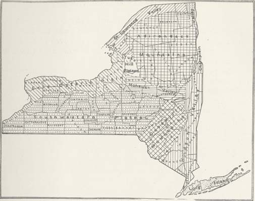
Showing the ten chief physiographic provinces into which the state is divided — Mohawk Valley, Hudson Valley, Long Island, Champlain, Adirondack Mountains, St. Lawrence Valley, Tug Hill Plateau, Erie-Ontario Plain, Catskill Mountains, Southwestern Plateau. From the Geological History of New York State by William J. Miller, Ph. D., reproduced by courtesy of Dr. Miller, who was professor of geology at Hamilton College, Clinton, Oneida County, at the time of the writing of this book.

Go to top of page | back to: Chapter 1

You are here: Home » Resources » MVGW Home » Maps » New York State Geological Provinces

http://www.schenectadyhistory.org/resources/mvgw/maps/nys_geological_provinces_map.html updated June 10, 2018

Copyright 2018 Schenectady Digital History Archive — a service of the Schenectady County Public Library

Statcounter