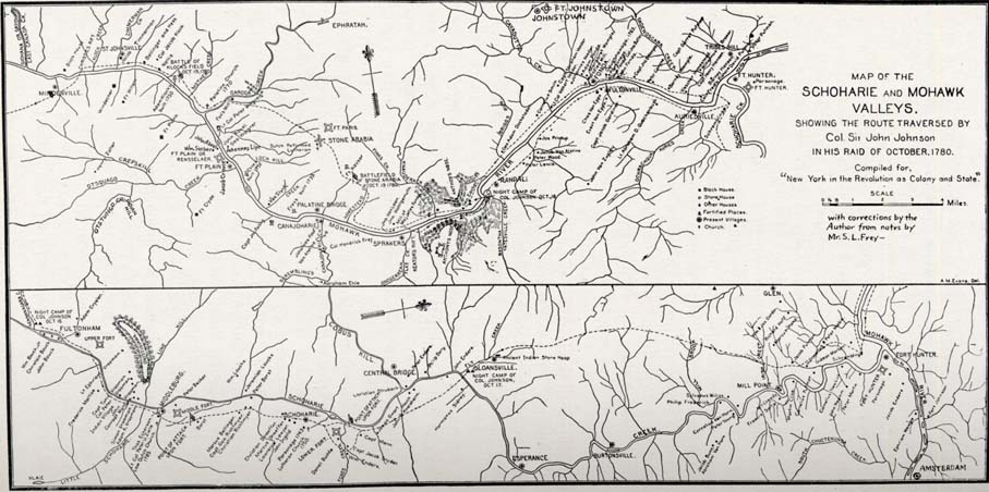
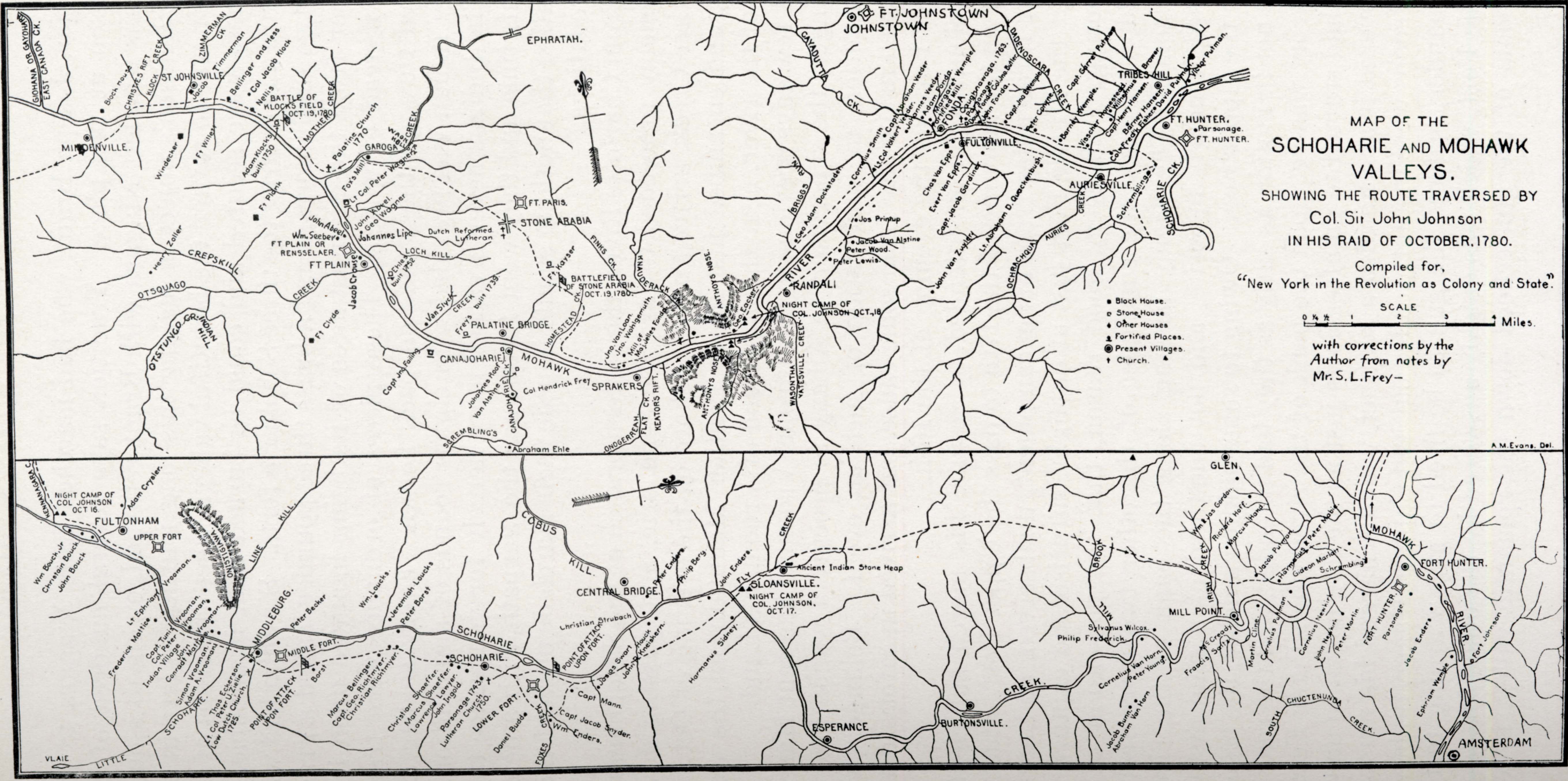
[View 9x enlarged (417K) and 36x enlarged (1027K) versions]
Map of the Schoharie and Mohawk Valleys, Showing the Route Traversed by Col. Sir John Johnson in His Raid Of October, 1780. Compiled for "New York in the Revolution as Colony and State."
Scale 4 Miles = 1.25 inches [as printed in the book]
with corrections by the Author from notes by Mr. S. L. Frey.
Notes: this illustration consists of two maps, one following the Mohawk River from the [Giohana / Gayohara] East Canada Creek and Mindenville in the west to Fort Hunter and the Schoharie Creek in the east. The other (rotated 90 degrees clockwise) follows the Schoharie Creek north from Fultonham and the Kennanagara Creek to Fort Hunter and Amsterdam on the Mohawk River.
Names on the upper map roughly from left to right (west to east) and top to bottom include:
first quarter of map: Christies Rift, Klock Creek, St. Johnsville, Zimmerman Creek, Jacob Timmerman, Windecker, Fort Willett, Henry Zoller, Crepskill Creek, Otsquago Creek, Otstungo Creek, Indian Hill, Bellinger and Hess, Col. Jacob Klock, Nellis, Adam Klock's built 1750, Fort Plank, Battle of Klock's Field Oct 19, 1780, Mothero Creek, Palatine Church 1770, John Abeel, William Seeber, Fort Plain or Rensselaer, Fort Clyde, Jacob Crouse, Garoga Creek, Fox's Mill, Lt. Col. Peter Wagner, John Abeel, George Wagner, Johannes Lipe, Wagner Hollow, Loch Kill, Ehle's built 1752, Capt. Jno. Failing, Van Slyck
second quarter of map: Dutch Reformed Lutheran, Frey's built 1739, Scrembling's, Ephratah, Fort Paris, Stone Arabia, Palatine Bridge, Canajoharie, Johannes Roof, Van Alstine, Col. Hendrick Frey, Canajoharie Creek, Abraham Ehle, Fort Keyser, Homestead Creek, Finks Creek, Battlefield of Stone Arabia, Oct 19, 1780, Jno. Van Loan, Jno. Wohlgemuth, Mill of Major Jelles Fonda, Sprakers, Onogerreah, Knauderack Creek, Flat Creek, Keator's Rift, Anthony's Nose, George Eacker, Night Camp of Col. Johnson Oct. 18
second half of map: Briggs Run, George Adam Dockstader, Randall, (Wasontha) Yatesville Creek, Cayadutta Creek, Fort Johnstown, Cornelius Smith, Capt. Abraham Veeder, Lt. Col. Volkert Veeder, Johannes Veeder, Adam Fonda, Jos Printup, Jacob Van Alstine, Peter Wood, Peter Lewis, Margaret Wemple, Fortified Mill, Fonda, Caughnawaga 1763, Parsonage, Douw Fonda, John Fonda, Col. Jno. Butler, Chas Van Epps, Evert Van Epps, Capt. Jacob Gardiner, John Van Zuyler, Capt. Jno. B. Wemple, Lt. Abraham Quackenbush, Peter Conyne, Dadenoscara Creek, Barney Wemple, Ochrachqua Creek, Visscher Homestead, Auriesville, Wilhelmus Brower, Capt. Henry Hansen, Barney Hansen, Col. Frederick Fisher, Schrembling, David Putman, Victor Putman, Fort Hunter, Parsonage, Schoharie Creek
Key to symbols: Block House, Stone House, Other Houses, Fortified Places, Present Villages, Church
[At lower right corner of upper map is the note "A. M. Evans, Del"]
Names on the lower map roughly from left to right (south to north) and top to bottom include:
first quarter of map: Kennanagara Creek, Night Camp of Col. Johnson Oct 16, William Bouck, Jr., Christain [Christian?] Bouck, John Bouck, Fultonham, Adam Crysler, Upper Fort, Lt. Ephriam [Ephraim?] Vrooman, Frederick Mattice, Capt. Tunis Vrooman, Col. Peter Vrooman, Indian Village, John Vrooman, Conradt Mattice, Simon Vrooman, Adam A. Vrooman, Vlaie, Little Schoharie, Onistigiawa [Onistagrawa?], Line Kill, Thomas Eckerson, Lt. Col. Peter U. Zielie, Low Dutch Church 1725, Middleburg, Peter Becker, Middle Fort, Point of Attack Upon Fort, Borst, William Loucks, Jeremiah Loucks, Peter Borst, Marcus Bellinger, Capt. George Richtmeyer, Christian Richtmeyer
second quarter of map: Schoharie, Schoharie Creek, Christian Shaeffer, Marcus Shaeffer, Lawrence Lawyer, John Ingold, Parsonage 1743, Lutheran Church 1750, Lower Fort, Daniel Budd, Cobus Kill, Foxes Creek, Point of Attack Upon Fort, William Enders, Capt. Jacob Snyder, Capt. Mann, Josias Swart, Central Bridge, Christian Strubach, Peter Enders, Houck, John P. [or R.] Kneiskern, Philip Bery, John Enders, Harmanus Sidney, Fly Creek, Sloansville, Night Camp of Col. Johnson, Oct. 17, Ancient Indian Stone Heap
second half of map: Esperance, Burtonsville, Mill Brook, Philip Frederick, Sylvanus Wilcox, Cornelius Van Horn, Peter Young, Jacob Bunn, Abraham Van Horn, Glen, Mill Point, William and Jas Gordon, Richard Hoff, Marcus Hand, McCready, Francis Saitz, Martin Cline, Jacob Putman, Harmanus and Peter Mabie, Cornelius Putman, Gideon Marlatt, Cornelius Newkirk, John Newkirk, Schrembling, Peter Martin, Mohawk River, Fort Hunter, Parsonage, Jacob Enders, Ephriam [Ephraim?] Wemple, Amsterdam, Fort Johnson