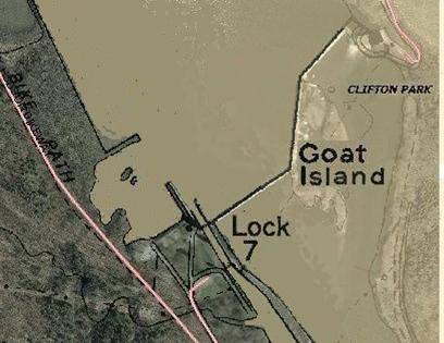
Between Rexford and Vischers Ferry, the Erie Canal had coursed separately along the Clifton Park side of the river. A central objective in planning the Barge Canal focused on producing the longest practical flat stretches with higher lifts among far-fewer locks. To exploit the river's steep fall from Rexford to Waterford, another objective included generating power year-round.
Crescent (above Cohoes) and Vischers Ferry provided favorable locations for power-dams while also coordinating with appropriate arrangements for locks. Presumably, Lock 7 and the power-generating facility could not function on the same side of the river without interference, so their specific north- and south-side locations near Vischers Ferry arose from satisfying the ready accessibility each required in the most practical manner. The pool-to-pool locking function for navigation along the Barge Canal shifted to the Niskayuna side to provide the straightest channel in the respective pools to and from the lock.
After completion of Lock 7 in Niskayuna for the Barge Canal, the former Erie Canal site became available as an already accessible location for the new hydro-power facility (upper right in Figure 2 below [Source: Schenectady County Planning Department]).
 Raised by the power-dam to create the pool needed for navigation between here and Lock 8 upriver, the resulting width is approximately three times more than elsewhere upriver along the flowpath.
The specific locations chosen for the two operating facilities were offset, resulting in an unusual twice-bent foot-print of the nearly 2,000-feet long power-dam.
Diverting flow to spin the turbines in the power facility at the northern end (upper right) usually results in little or no overflow along the dam itself until significant rains, snow-melt, etc. within the drainage basin result in greater discharges.
That the two separate functions of locking from pool-to-pool and power generation at a permanent dam occurred at, after the canal-pool rose into the topography along the Clifton Park side, the widest normal bank-to-bank point along the entire pool within Schenectady County has proven to be consequential to Schenectady. Consider that the usual slow flow past narrow points upriver becomes stalled here as it approaches this dam, thereby promoting thick ice.
The new power-dam required permanency, so concrete was the choice. It has produced a 27-feet difference in pool-levels, which Lock 7 and channeling accommodate for navigation.
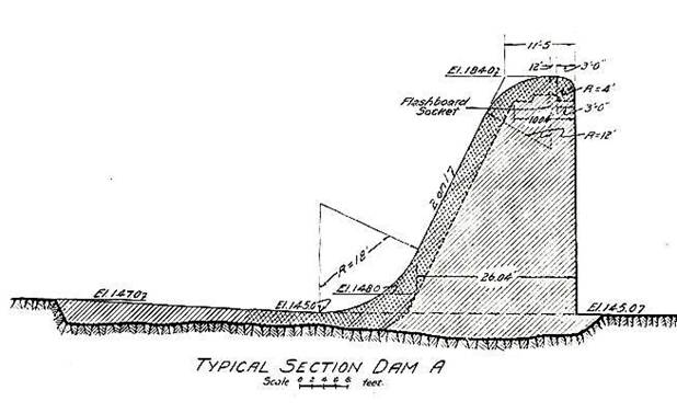
Figure 3 [Source: "Book of Plans, New York State Barge Canal, Supplement to Annual Report, State Engineer and Surveyor, 1920, Frank R. Williams, State Engineer" (as resourced by Katherine Chansky, Librarian, Schenectady County Historical Society).
The above drawing (Figure 3) is one element on a page with its title including "…A LONG SPILLWAY FOR FLOOD DISCHARGE" — a strategically revealing phrase. While this drawing, the only one found or available during this investigation, pertains to the Crescent dam impounding the pool below Vischers Ferry Dam and is to-scale for the conditions and needs at that lower location, it serves generically here to illustrate the basic form used and dimensioned for conditions at Vischers Ferry. Across their entire length and as-built, the actual fixed crest and spillway are uniform and "without movable parts". (4) This structure lacks any explicit features, mechanisms or other substantial means for short-term active management to avoid or minimize flood-stages at Schenectady and mitigating the impacts there.
Instructive is the fact that, with many dams on the nation's largest rivers, the US Army Corps of Engineers routinely accepts the working principle for capacity "controlled by the navigation locks and dams" to manage the expected natural variations in discharge. (5) Clearly, toward any semblance of short-term relief, and ignoring the matter of "control", no significant attempt existed at Vischers Ferry Dam — only the overflow. Despite the many floods during only the recent four decades, no efforts have occurred to modify the structure with relief-measures.
As Figure 3 indicates, the upriver side is vertical with a slight rounding of the "edge" along the crest, and the applied flashboards raise the pool at least two feet with normal summer flow.
Overall, regarding the early-20th century engineering design process to determine the basic character and consider possible operating features for the permanent dam at Vischers Ferry, one matter is clear — and it is evident during free-flow events without any complications by ice.
To the designers, when the expected larger and sometimes tremendous discharges from upriver would swell this pool, the very long crest would allow an easy passive overflow sufficient to prevent any significant flood-stage in Schenectady.
Reality proves otherwise. The dam's upright form and totally "fixed" character at this wide location result in at-least one outcome evidently unexpected by its designers. Overflows along the crest (and flashboards) reach stunning heights while or after raising the entire "flat" pool, and not avoiding or minimizing flood-levels at Schenectady.
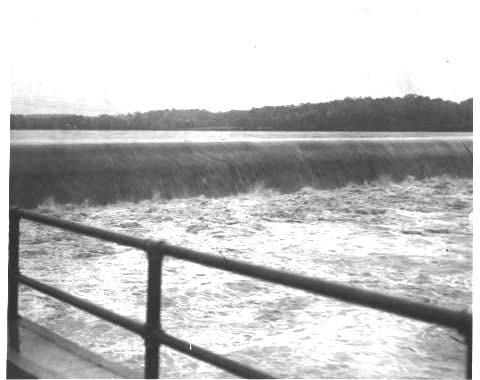
[Source: Historical Photo Collection, Efner History Center, Schenectady City Hall, courtesy of Cynthia Seacord]
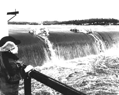
The above three photos of overflows at the dam (left and center include flashboards) represent flood-stage events occurring then at Schenectady. With such dramatic deep overflows along a crest more than three times wider than the flow at Schenectady, what is causing simultaneous flood-levels so far upriver — and during free-flow?
First, any widespread and prolonged precipitation in the drainage basin that exceeds the throughput capacity of the power facility must overflow the dam, as intended, while the flash-boards not only raise the pool-level, but also greatly increase the resistance to flow. Furthermore, the smooth-surfaced overflow masks that the deep vertical face of the dam causes significant subsurface turbulence in the torrent approaching from upriver. With the edge of the crest only slightly rounded, and nothing to help raise more of the torrent to overflow readily, the swirling turbulence probably starts only a few feet below the crest and undoubtedly extends far beyond. Suspicion arises that a substantial volume of water swirls in the width of the lower pool, perhaps counter-flowing upriver for a distance before re-engaging with the overall discharge above — the start of backwater raising the base-pool under the swollen discharge coming downriver! Thus, the reliance solely on the crest's length for overflow above its unrelieved vertical face results in a high pool-level at Schenectady during voluminous free-flow or open-water, too often to flood-level and above. The flashboards accentuate this obstruction.
Unclear is how the understandings and decisions in design long ago respected the other important seasonal situation — ice — the history of massive break-ups, supposedly the dominant factor in flooding at Schenectady, and their force within the overall Niskayuna-Schenectady Pool. The designing occurred so long ago that speculating is our only role now, but with new reasoning based on damaging experience, many observations and … knowing the dam's form.
Significantly downriver from the Narrows and the Knolls, the power-generating facility (Figure 4 below) demands most of whatever current remains normally year-round at this widening end of the Niskayuna-Schenectady Pool. During winter low-flow, this fact is very important.
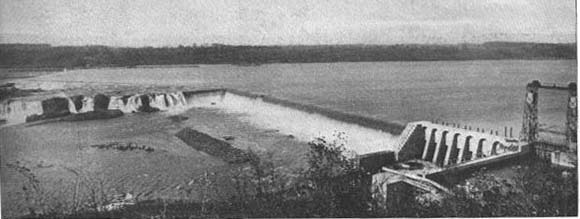
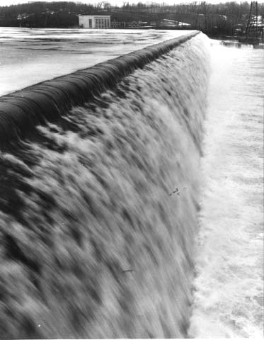
Figure 4 [Source: William B. Efner Collection, 1918 Barge Canal Bulletin, courtesy of Cynthia Seacord]
View of Vischers Ferry Dam, showing the sections across each of the two river channels and the section upon the intervening island, also the lock at the distant end — reportedly photographed in 1913 during active flow (and showing at the lower right corner sluice gates for the yet-unbuilt power-generating facility).
As the priority to generate power at the Clifton Park end diverts the normal "current" to the sluice gates (Figure 4 above), the only consistent opening in the dam, the overall lack of current across the wide dam stimulates an early ice-sheet, undoubtedly becoming the thickest on the entire pool and extending far upriver toward the Knolls.
With the overall normally "stalled" flow (lack of current) at this wide location (and in much of the flat pool), this overall design produces a probably unexpected, highly consequential outcome when thaws and ice breakups occur upriver during winter.
Allowing undisturbed thick sheet-ice with great structural integrity to form directly at the dam and then extending upriver (coupled with frictional resistance along much or most of the shoreline), thus readily promotes damming of the arriving ice-floes, hence the jamming observed so-often "at the Knolls" as water levels increase upriver.
Accordingly, many of the ice-jams downriver from Schenectady relate to the unmanageable pool-level impounded by that physically inflexible dam. That ever-present volume of water is a physical base over which build any and all increased discharges from upriver, especially whenever high-volume discharges occur, whether ice-laden or not.
Whatever might be the constraints to free-flow as imposed by the geologic formation of gorge and tight bend below Rexford, they are relatively minor while something more-strategic applies. That "something" is the Niskayuna-Schenectady Pool. We cannot "pin" or "hang" the warm-weather flood-levels and corresponding depths of the overflows at the Vischers Ferry Dam on anything other than what exists THERE — the form of the totally passive dam. As only one example, the June 2006 event shows the reality of the unforgiving restriction at the Vischers Ferry Dam that causes the pool to rise, enter structures and remain for a disturbing period.
Over many decades, officials' stated reasons for not modifying the Vischers Ferry Dam and the normal pool-level have related to (a) navigation, (b) production of power and (c) re-charge for the municipal water-supply wells, more than eight miles upriver on the great Flats Aquifer. These defensive, bureaucratic excuses are invalid as objections to seeking and applying short-term measures proactively preparing (gradually lowering, opening… etc.,) as forecast high-discharge events or understood ice-flows approach and acting appropriately during the events, followed by promptly restoring the pool-level as conditions allow.
The benefits of reducing the physical interruptions, outright and concealed damages, expenses, reduced property values and quality of life near the waterfront at Schenectady should outweigh the small collateral impacts of possible briefly reduced recharge of the Great Flats Aquifer or slightly less power from the New York Power Authority's generating facility. During floods or ice-flows, navigation is not an issue.
Greatly increased capability in all scales or ranges of weather forecasting and computer modeling of hydrology is available now and improving constantly. Local alerting networks have improved. The faulty century-old design for the Vischers Ferry Dam remains as-built. Thus continues the original vulnerability at Schenectady. The time has come to modify that dam with mitigating capabilities to match what we can understand and foresee about weather.
From the two seasonally separate floods at Schenectady within less than a year, especially the free-flow in June 2006, the now-understood characteristics of the dam generate at least one inescapable and seemingly reasonable hypothesis.
Without some new pool-reducing means available and procedures used prior to and during expected weather-events to allow a flow at a sufficiently high rate through or past that dam more than only over its spillway, the open vulnerability at Schenectady will continue ad infinitum with the attendant damages, costs, physical disruptions, human anxieties, etc.
Footnotes
(4) "The Story of the New York Sate Canals, Historical and Commercial Information", Roy G. Finch, State Engineer and Surveyor, 1925, revised 1998.
(5) "Mohawk River, NY — US Dept of the Army, Schdy", R 627.5 U58, Schenectady County (Main) Library, p. 13