The Figure 1 below represents the upriver-fed 1825 Erie Canal crossing the early city as an inland waterfront, while new railroads nearby began to connect within the region.
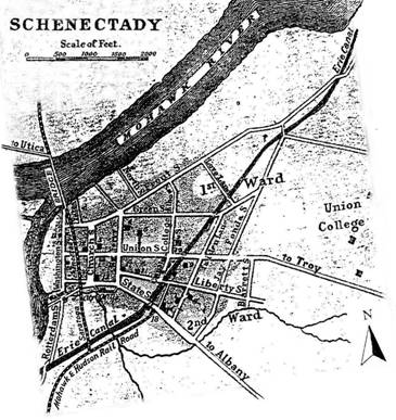 Experience with floods had limited early development to high ground to the area from near State Street northward across Front Street (parallel to the river) and eastward toward Jay Street as the Erie Canal arrived.
Land shown in the southwestern "corner", much-lower than State Street and road to Albany, was naturally prone to flooding by the river-tributary Binnekill (left margin), so it remained mostly undeveloped — until widening of the Erie Canal for a harbor (near the railroad). Then construction proceeded actively in that overall area.
History parallels 1860's statewide enlargement of the overall Erie Canal with more-frequent destructive flooding at Schenectady.
The more development in the lowland, the more impactful was the flooding and news about damages — especially after 1886, when Thomas Edison bought land (at "Figure 1" and beyond) for his business, shortly to be the new GE's home for decades.
The river and its usual inundations at Schenectady remained mostly as when Arendt van Curler first came in 1661 (rather than the higher-level we know now as the canal's pool). Overflows of the Erie Canal disrupted and damaged the extensive development around the new harbor in the lowland, as well as all else across the area from SCCC to the I-890 Exit 5 (Broadway) and to the slope near the "Lottery Building" (before the earth embankments raising the railroads divided this overall area at the end of the 19th century).
Listings in the report, "A Chronology of Floods and Flood-Related Events in the Schenectady Sector of the Mohawk River", a very valuable resource, provide a "series of dates and events … from the sources available" to depict the history of major flood events, most during the "Barge Canal period" (1910-present). (1) This section excerpts a few selections, while Appendix A herein broadly excerpts pertinent portions of that report's basic chronology.
An "Addendum No. 20", a sort-of executive summary, begins the "Chronology" report, focused on the succession of canals, largely on the NYS Barge Canal's Vischers Ferry Dam and the Niskayuna-Schenectady Pool it impounds west to Lock 8. Following are excerpts from it:
"…destructive floods more frequently since 1865… enlargement of the Erie Canal… Following 1910, the flood record becomes more conspicuous… a major change in the watershed… establishment of the N.Y.S. Barge Canal."
Pages 8-14 of the "Chronology" report list dates of many floods and the stages at Schenectady. Construction of the Vischers Ferry Dam for the Barge Canal began in 1907. Flooding occurred in Schenectady during March 1910, as that dam and its pool rose. A flood occurred in 1913, when the Niskayuna-Schenectady Pool had filled, further complicating the vulnerability present in the downtown-crossing Erie Canal and its harbor — then flooding recurred in 1914 and 1916.
A photo of the flooding on 3/28/1914, included the notation, "…sloshing through (new east side of Erie Boulevard) as water from the swollen adjacent Erie Canal spilled over the street." (italics added) (Schenectady Gazette, 3/25/1980)
For the very damaging events in March 1914 and 1916, copied newspaper accounts (requiring 51 pages to cover lengthy columns) provide day-to-day reports of observations. Three very critical assessments of the new Vischers Ferry Dam appear among the reports (as outlined in the next section, "Swift and Critical Commentary…", and provided fully in Appendix B). The report includes 14 pages of local historical background and concludes with 9 pages of later information derived from documents provided by the US Army Corps of Engineers.
Within the numerous gleaned excerpts appearing as Appendix A herein, notations of "at", "opposite" or "from", "the location of" the Knolls appear often. In several instances, a reference to "…Vischers Ferry Dam" occurs.
The matter of ice-jams took on new dimensions, as later sections will discuss. Those occurring below Lock 8 and at the railroad bridges began with a raised new low-flow pool, not as previously. From Rexford downriver, the level and flow was entirely new, high and slowed. With the abandoned Erie Canal filled during the early 1920's, storm runoff sewers rebuilt to coordinate with the raised pool and an earth dike built along Washington Avenue in 1940 ceasing most danger of river flooding to the interior, floods by the Barge Canal-pooled Mohawk River have affected mostly residential properties. Then came the late-20th century SCCC campus developed on a previous low peninsula/island (within "the flood plain").
The current NOAA-NWS "Advanced Hydrologic Prediction Service" website lists these "historical crests" (in order of lesser flood stages) at Schenectady.
- 03/28/1914: 232.90'
- 03/19/1936: 229.20'
- 03/28/1913: 228.90' — Free-flow (according to the "Chronology" report)
- 01/20/1996: 228.00'
- 03/15/1929: 227.70' — Free-flow (according to the "Chronology" report)
The months of these five dates imply that ice jams probably occurred at some location(s) and sequence among the overall swollen discharges — but do observe also the noted "free-flows".
Regarding the matter of flood stages — evidence exists that not all readings and records might refer to the same baseline. Regardless, the issue is the excessive overall extent of physical vulnerability at Schenectady many miles upriver from the Vischers Ferry Dam.
The many "lesser" floods always disrupt and involve a variety of negative long-term physical implications, such as concealed structural rot, mold, etc. For example, during "the dinner-hour" of 27 December 1973, an ice-jam slightly upriver from the Western Gateway Bridge broke, a 227.5' flood stage sped up the low-lying portions of four "usual problem" streets in the Stockade. It then receded totally within a few hours a la a miniature tsunami, leaving numerous cellars filled with river water and many 4-5' high ice-blocks almost continuously lining Riverside Park until they melted fully.
Footnotes
(1) By Mary van der Bogart, Chair of the Schenectady Riverside Flood Research Committee of the Flood Assessment Task Force for the Schenectady County Chamber of Commerce, 8 February 1978, available as custom-bound "Schenectady R 627.5 S32" (from storage upstairs) at the Main Library in Schenectady (other than a copy at the Schenectady County Planning Department, locations for more copies of this report are unknown at this time).